
A Flash Flood WATCH is currently in effect for El Paso county, including UCCS, until midnight. An additional Flash Flood WATCH has been issued for Saturday from 12:00pm to midnight. For additional forecast details, visit www.weather.gov/pub
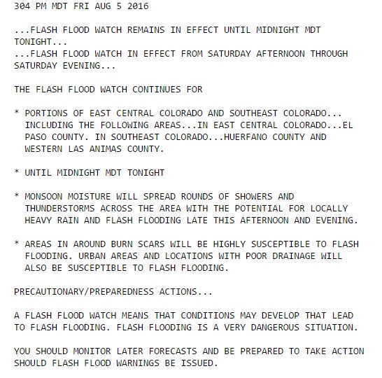


A Flash Flood WATCH is currently in effect for El Paso county, including UCCS, until midnight. An additional Flash Flood WATCH has been issued for Saturday from 12:00pm to midnight. For additional forecast details, visit www.weather.gov/pub
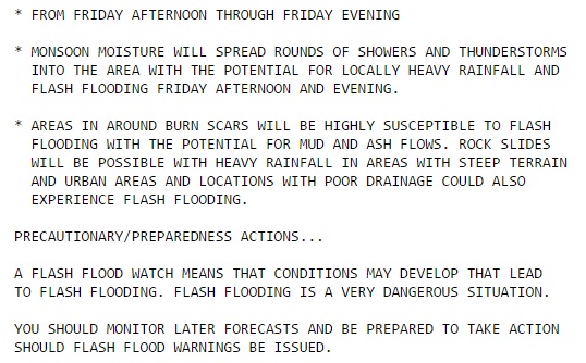
UPDATE: The Flash Flood Watch has been updated with respect to the time frame, and is now in effect from 4:00pm to midnight today.
A Flash Flood Watch has been issued for El Paso county, including our UCCS campus, from 12:00pm to midnight on Friday, August, 5, 2016. A Flash Flood Watch means that conditions are favorable for flash flooding to occur.
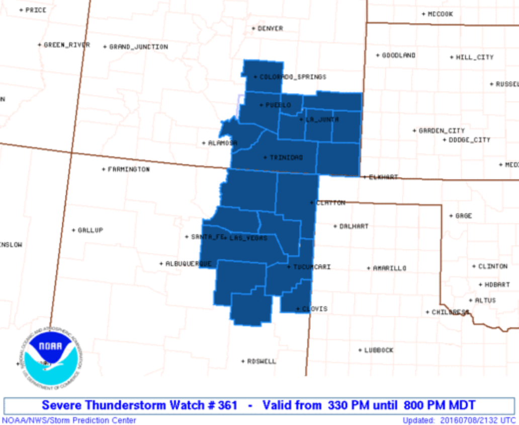
Severe Thunderstorm WATCH issued until 8pm MDT, includes UCCS. Stay weather aware and tuned in to local media for warning information, or visit www.weather.gov/pub
UPDATE: The Flash Flood Watch has been cancelled. (8:00pm)
A Flash Flood WATCH has been issued from 12:00pm – midnight today:
Be aware, have a plan, and take action if needed. For more forecast information, visit www.weather.gov/pub

Severe Thunderstorm Warning issued until 2:45pm, hail to 1″ and 60mph winds possible. Seek shelter indoors until the storm has passed.

Flood Advisory issued until 10:15pm, avoid water-covered roadways and areas of fast-moving water. Monitor for latest warning info at www.weather.gov/pub

Severe Thunderstorm Warning issued until 8:15pm…large hail and damaging winds possible. Seek shelter indoors until the storm has passed.

A Flash Flood Warning has been issued until 9:15pm.
– Avoid driving through water-covered roadways
– Avoid areas of running water
– If your windshield wipers are on your headlights should be too
Stay dry, stay safe!

At 1:25pm the Storm Prediction Center issued a Tornado Watch for much of eastern Colorado, including El Paso county, until 9:00pm MDT. Additional information can be found at http://www.spc.noaa.gov/products/watch/ww0250.html
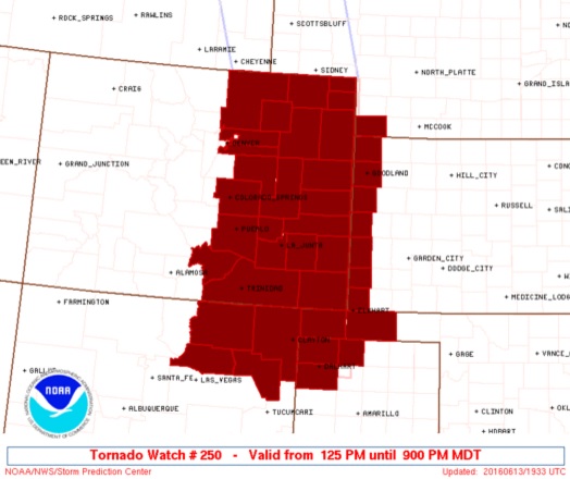
Tornado Watch issued until 9:00pm MDT
 * PRIMARY THREATS INCLUDE...
     A COUPLE TORNADOES POSSIBLE
     SCATTERED LARGE HAIL AND ISOLATED VERY LARGE HAIL EVENTS TO 3
       INCHES IN DIAMETER POSSIBLE
     SCATTERED DAMAGING WIND GUSTS TO 70 MPH POSSIBLE

   SUMMARY...WITHIN A MOIST ENVIRONMENT...STORMS WILL CONTINUE TO
   INCREASE INITIALLY ACROSS PARTS OF EASTERN COLORADO AND NORTHEAST
   NEW MEXICO. SUPERCELLS CAPABLE OF LARGE HAIL CAN BE EXPECTED THIS
   AFTERNOON...PARTICULARLY ACROSS SOUTHEAST COLORADO AND NORTHEAST NEW
   MEXICO. A TORNADO THREAT WILL EXIST PARTICULARLY AS STORMS MOVE
   EASTWARD TOWARD AN INCREASINGLY LOW-LEVEL JET EARLY THIS EVENING.
   THIS LOW-LEVEL JET MAY ALSO SUPPORT UPSCALE GROWTH INTO A LINEAR
   CLUSTER OF STORMS TOWARD PARTS OF KANSAS AND THE OKLAHOMA/TEXAS
   PANHANDLES.

   THE TORNADO WATCH AREA IS APPROXIMATELY ALONG AND 65 STATUTE
   MILES EAST AND WEST OF A LINE FROM 55 MILES NORTH OF AKRON
   COLORADO TO 30 MILES WEST SOUTHWEST OF DALHART TEXAS.  FOR A
   COMPLETE DEPICTION OF THE WATCH SEE THE ASSOCIATED WATCH OUTLINE
   UPDATE (WOUS64 KWNS WOU0).

   PRECAUTIONARY/PREPAREDNESS ACTIONS...

   REMEMBER...A TORNADO WATCH MEANS CONDITIONS ARE FAVORABLE FOR
   TORNADOES AND SEVERE THUNDERSTORMS IN AND CLOSE TO THE WATCH
   AREA. PERSONS IN THESE AREAS SHOULD BE ON THE LOOKOUT FOR
   THREATENING WEATHER CONDITIONS AND LISTEN FOR LATER STATEMENTS
   AND POSSIBLE WARNINGS.
The National Weather Service in Pueblo has issued a Winter Weather Advisory for our area from midnight to 9:00pm on Saturday, March 26, 2016. Stay tuned in to the latest forecast details, particularly if you have travel plans during the period. More details can be found at www.weather.gov/pub
THE NATIONAL WEATHER SERVICE IN PUEBLO HAS ISSUED A WINTER
WEATHER ADVISORY FOR SNOW...WHICH IS IN EFFECT FROM MIDNIGHT
TONIGHT TO 9 PM MDT SATURDAY. THE WINTER STORM WATCH IS NO LONGER
IN EFFECT.

* LOCATION...SOUTHERN EL PASO COUNTIES.

* CAUSE AND TIMING...A MOIST PACIFIC STORM SYSTEM WILL SPREAD
  SNOW ACROSS THE AREA TONIGHT THROUGH SATURDAY...WHICH COULD
  BECOME LOCALLY HEAVY AT TIMES...ESPECIALLY THIS EVENING
  THROUGH SATURDAY MORNING.

* SNOW ACCUMULATION...2 TO 5 INCHES.

* WIND...NORTHEAST 10 TO 20 MPH.

* IMPACT...ROADS WILL BECOME SLICK...SNOWPACKED AND ICY WITH
  RAPIDLY CHANGING CONDITIONS UNDER THE HEAVIER SNOW BANDS THIS
  EVENING THROUGH SATURDAY MORNING.